20 Feb COSTEP Provides Tool for Centralized Uniform Data
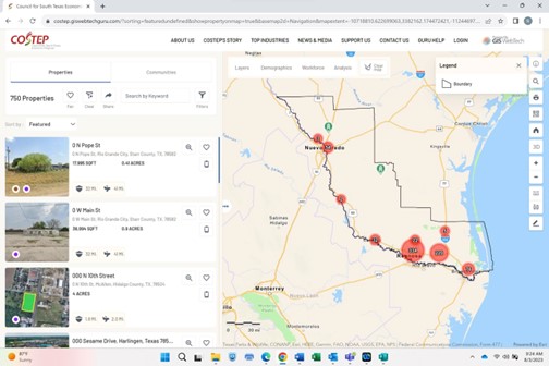
COSTEP, Council for South Texas Economic Progress is providing the GIS Webtech Guru platform to local economic development organizations (EDOs) and all community stakeholders with the intent of having centralized uniform data available for the promotion of the region. The platform has over 1,000+ properties from around the seven-county region served by COSTEP at any given time. Properties are regularly updated, being listed or removed based on their availability. The tool also has the ability for authorized users to add properties that are not listed on property databases, as in the case of an owner represented property. The intent is to have a centralized data platform that the entire region can use to market the region for industrial and commercial attraction.
GIS Webtech Guru
COSTEP’s GIS Webtech Guru platform provides ESRI data. Visitors to the platform can pull up data at various levels. This includes, by COSTEP service region, individual counties, city, and census tract. The platform also allows to select a needed geographic location such grouping multiple counties, cities or census tracts, or user drawn geographies. The platform provides users with labor, consumer, market demographics, and psychographic reports. The platform allows for trade area analysis via ring analysis and drive time.
COSTEP provides this data tool at no charge to EDOs and site selection professionals nationally and internationally. Access to the platform is quite simple. Just go to the COSTEP website and clicks on the “Find A Property” or “Find Rio South Texas Data” tabs in the center of the home page. COSTEP provided two virtual workshops on how to use the platform last year, July and September of 2023. Videos of those workshops can be found on the COSTEP website under the “News & Reports” tab, “Videos” subheading. For more information on the GIS Webtech Guru platform, contact Rick Carrera at (956) 638-9959, rcarrera@costep.org.


