Both Oars in the Water
January 4, 2022
How the Rio Grande River is an Everlasting Connection Between Two Countries and Their People
by Faith Chua
What do you think of when you hear the word "border?" The Cambridge dictionary defines it as “the line that divides one country or place from another.” The Merriam-Webster dictionary defines it as a boundary or “something that indicates or fixes a limit or extent.” No matter where you look, the word border indicates division and separation. However, for the Rio South Texas region, the border is anything but divisive.
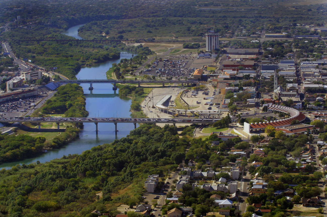
Looking at a map, the Rio Grande River (known as Rio Bravo or “Brave River” by residents on the southern riverbank) looks as though it would divide the United States from Mexico. However, rather than divide the two nations, it serves to connect them. From an economic and cultural standpoint, the river sees thousands of people and commercial goods traveling between the two countries across its system of bridges on a daily basis. These bridges have become essential aspects of daily trade, not only to the region but also to businesses across the nation and around the globe.
“These bridges [of Rio South Texas] are the arteries of the region,” said the Counsel for South Texas Economic Development Progress (COSTEP) Vice President for Economic Development, Matt Z. Ruszczak.
One of the main connecting points in the region is the Laredo International Bridge System.
According to the bridge’s website, its mission is “to serve as the most convenient and safe crossing points for all citizens and tourists of both U.S. and Mexico, as well as facilitate the crossing of all freight and import-export trade that utilizes the Port of Laredo.”
One look at the crossing’s annual statistics verifies that the Laredo International Bridge System meets this goal with aplomb. The Laredo International Bridge System is by far the number one truck border crossing in the United States with 2,133,327 crossings for the first 10 months of 2021, almost twice the quantity of the number 2 ranked crossing, with 1,162,478 trucks for the same time period. Additionally, the Laredo International Bridge System truck crossing numbers are up 11.7% compared to the same time period in 2020, and they are also up 6.7% compared to the first 10 months in 2019, which outperforms pre-pandemic conditions.
Using the river to facilitate the transport of goods and people is nothing new to the Rio South Texas region, which dates back to at least the 14th century. While the Rio Grande/Rio Bravo had been part of daily life for centuries, it wasn’t fully mapped until the passing of the Treaty of Guadalupe Hidalgo in 1848. Around this time, steamboats, which had become popular throughout the United States, were also used on the river. While today’s river is no longer as deep and as wide as it used to be, due to the dams built in the past decades for irrigation purposes, the history, culture, and importance of the river runs deeper than ever.
For those who live in the region, that border, delineated by the river, is a means to connect, trade, and collaborate with others. Being at the connecting point of the U.S. and Mexico allows for a distinct and rich culture to grow and for future-oriented commerce to thrive. Rio South Texas is a unique region due to its history and geographic location, and COSTEP invites the rest of the world to explore the opportunities it provides.
For more information on Rio South Texas, follow the organization on Facebook, LinkedIn, and Twitter: @costep
ADD ITEM TO REPORT
As you navigate our website, you can use the “Add Item to Report” button to add any page or property to a custom report that you can print out or save.